|
Although most of Cadron Creek is floatable no one in recent years has paddled the
entire length of Cadron Creek from Gravesville to Cadron Settlement. Moreover no one has even published a guide to assist in planning such an adventure. The following "mile markers' are hopefully the start to a project that will see both of the above goals come to fruit. In the interim please use them to help you in planning your adventure on Cadron Creek. |
|
Upper East Fork of Cadron Creek - 8 Miles
The stretch from Highway 36 bridge to Highway 107 bridge is the most popular stretch on the East Fork of Cadron Creek.
Tubelo gum trees shade the water as it changes abruptly from calm pools to tumbling rapids every few hundred feet. In high water, standing waves can swamp open canoes and the tupelos in the path of fast current can be canoe wreckers. Special attractions are Star Bluff, Buzzard's Root Mansfield Bluff and Rainbow Falls. |
|
Gravesville - Mile 0
Very intriguing. Cadron Creek is narrow and winding and trees
reaching across the creek conceal it from the sun. Easy float with many places to stop and fish. Long pools. Few rapids. |
|
With nearly 60 miles of floatable stream Cadron Creek Outfitters can
arrange a perfect adventure for you. We also provide service to Cove Creek, Archy Fork, East Fork of Cadron Creek, and the South Fork of the Little Red River as may be requested and available. And late summer "Bogoloosha" trips will provide relief from the sun and good fishing. |
|
8.6 Miles- Stream enters on right
10.1 Miles- Stream enters from left, Enter "Gooch Bend"
10.2 Miles- "Gooch Bend"
10.3 Miles- Stream enters from left, "Red Oak Bluff" on right
11.5 Miles- Middle Fork enters from left
11.9 Miles- Stream enters from left
|
|
14.0 Miles- Kennimer Branch enters from left
15.1 Miles- Utility Easement
15.2 Miles- Pumpkin Center Circle (uphill on left)
15.3 Miles- Stream enters from right
16.4 Miles- King Branch enters from left
17.1 Miles- Stillhouse Branch enters from left
|
|
18.4 Miles- Stream enters from right
18.8 Miles- Stream enters from left
20.0 Miles- Tucker Lane (uphill on left)
21.0 Miles- Batesville Mountain Campground
22.4 Miles- "Sparky's Minurets"
22.6 Miles- Wolf Pen enters from left
23.9 Miles- "Big Bluff Loop"
24.5 Miles- Stream from left
25.7 Miles- "Indian Rockhouse", Pinnacle Springs Campground
|
|
26.7 Miles- Pinnacle Springs Bridge
26.9 Miles- Stream enters on left, "Rain Shelter"
27.1 Miles- "Moo Poo Shoals"
27.4 Miles- "Pinnacle Gap", stream enter on right
27.5Miles- Stream enters on right, "Hidden Beauty"
27.9 Miles- "Owl's Nest Bluff", "Trickle Falls"
28.1 Miles- "Cathedral Shoals"
28.3 Miles- "Hidden Hollow Falls"
28.5 Miles- "Blow Out Bluff"
28.6 Miles - "Turkey" and "Turkey Island"
28.8 Miles- Stream enters from left
29.o Miles- "Ten Islands"
29.2 Miles- "Daddy's Knee", "Right At You"
29.4 Miles- "Bear's Cave"
|
|
30.5 Miles- River Camp #1
31.8 Miles- "Alum Bluff", "Alum Cave"
32.8 Miles- "T Loop"
33.0 Miles- Pontiac Lane uphill on right
33.9 Miles- Twin Groves Lane uphill on right
35.0 Miles- "Rock of Gibralter"
36.3 Miles- Stream enters from left
36.5 Miles- Big Peavine Creek enters from left
37.5 Miles- Stream enters from right
38.8 Miles- "illusion Bluff", "Pack and Grid Cabin"
39.8 Miles- Stream enters from left
|
|
40.5 Miles- Cove Creek enters from right
40.9 Miles- "Cascades"
41.0 Miles- Mallet Town Bridge and Cementary
43.5 Miles- Lick Branch enters from right
44.6 Miles- Springfield Road Bridge
53.5 Miles- Cypress Creek enters from right
54.0 Miles- Shaw Bridge Road
|
|
Cove Creek - 10.9 Miles
One of Cadron's Creek largest tributaries, Cove Creek, is floatable from Martinsville to Mallet Town during the wet spring
season. It is a beautiful tributary that has a number of natural attractions. These attractions include Devil's Chimney, a unique stepped, spire-like formation that looks as if someone piled rocks on top of one another, and Cove Creek National Recreaction Site. |
|
Lower East Fork of Cadron Creek - 10 Miles
From Highway 107 to the Hardin Bridge on county road 310, the creek flows along side White Oak Montain on the north for the
first few miles. This stretch has few difficulties and is floated more by fishermen than canoeists because of the many long pools and slower water, especially near the end as t creek enters the lowland area. Blue Hole is said to be the deepest on the pool on Cadron and is located about two miles beyond the put-in.. |
|
1.1 Miles- Utility Easement
2.1 Miles- Utility Easement
4.6 Miles- "Tight Twist Loop"
4.8 Miles- Stream enters on left
5.1 Miles- "The Bluffs"
|
|
County Road 610 - Mile 8.2
This stretch cuts through White Oak Mountain. Junction of the North
and West Forks of Cadron Creek at Gooch Bend. Open pastures and woods. Easy float with many places to stop and fish. Few rapids. |
|
Pinnacle Springs Campground - Mile 26.0
Popular access site with numerous rapids. Very scenic. Passes by
Pinnacle Points Gap, Blow-Out Bluff, Owl's Home Bluff and Bear's Cave. This may be Cadron Creek at its best. Nah. |
|
Highway 124 - Mile 12.7
Nice stretch for for those learning to canoe or desiring to take time to
fish. Bluffs get higher and rapids more numerous. At the bridge, rocks left from a dam mark the site of the old Hartwick grist mill washed away in the flood of 1927. |
|
Hartwick Mill Bridge - Mile 17.2
Popular stretch due to easier access and intense scenery. Moss
covered bluffs, rocky banks, wooded hillsides and waterfalls. Narrow chutes, numerous rapids and frequent obstacles. |
|
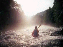
Highway 65 Bridge - Mile 30.0
Very challenging with churning rapids close to bluffs. The steep
bluffs are the highest and longest on Cadron Creek. The creek forks at various places with alternate channels floatable at higher levels. |
|
Highway 285 Bridge - Mile 40.0
Cadron Creek enters lowland and changes abruptly. Many long pools
and slower water. Deep holes and few obstacles. Motor boats often used by fisherman. |
|
An adventure awaits....
|
|
CADRON CREEK OUTFITTERS
54 Cargile Lane
Greenbrier, Arkansas 72058
(501) 679-5050
www.CadronCreekOutfitters.com
|
|
Paddler's Guide to Cadron Creek
|