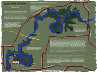
CADRON CREEK RIVER GUIDE
How many miles of river in the watershed can one paddle?
Combining all the forks of the Cadron -- East, Middle and North -- and all its major tributaries that offer off-the-grid exploration -- Cove Creek, Batesville Creek, Pine Mountain Creek, Beaver Creek, Clear Creek, Cedar Creek, and Cypress Creek -- there are over 200 miles of wonderful water here to paddle. And all just outside our back door!
Are they all accessible to paddlers?
Yes, we have personally enjoyed every river mile and invite to come enjoy the Cadron and its wonders for yourself. Whether coming for just an after-work adventure or a full week of expedition time on the Cadron will bring you back home and far away from the worries of the world. Guaranteed.
To help you navigate the many paddling options offered by the Cadron the following "mile markers" may be used as a guide:
Gravesville - Mile 0 (Black Hill Road Bridge)
Very intriguing. Here the Cadron is narrow and winding
and the trees conceal it from the sun.
Easy float with many places to stop and fish.
Long pools. Few rapids.
1.1 Miles - Utility Easement
2.1 Miles - "Cherokee Treaty Boundary", Easement
4.6 Miles - "Tight Twist Loop" (Class I - II)
4.8 Miles - Stream Enters on Left
5.1 Miles - "The Bluffs" (Class I+)
County Road 610 - Mile 8.2
This stretch cuts though White Oak Mountain.
Junction of the North and Middle Forks of the Cadron.
Gooch Bend. Open pastures and woods.
Easy float with many places to stop and fish A lot of wildlife.
8.6 Miles - Stream enters on right
10.1 Miles - Stream enters on left, "Gooch Bend Cut"
10.2 Miles - "Gooch Bend" (Class I+)
10.3 Miles - Stream enters from left, "Red Oak Bluff"
11.5 Miles - Middle Fork enters from left
11.9 Miles - Stream enters from left
Highway 124 - Mile 12.7
Nice intimate stretch offering a slow to moderately paced float trip suitable for larger groups and families.
Great for the lone fisherman or paddler looking to get away from it all. Bluffs get higher and rapids are more numerous.
Our favorite winter run for icicles -- ice climbing is so cool!
14.0 Miles - Kennimer Branch enters from left
15.1 Miles - Utility Easement
15.2 Miles - Pumpkin Center Circle (uphill on left)
15.3 Miles - Stream enters from right
16.4 Miles - King Branch enters from left
17.1 Miles - Stillhouse Branch enters from left
Hartwick Mill Bridge - Mile 17.2
Paddlers will find moss covered bluffs, wooded hillsides, waterfalls and a pleasant adventure.
Pace picks up after Batesville Mountain Campground with narrow chutes, numerous rapids and frequent obstacles.
Nice stretch for those learning to paddle or taking time to fish.
17.3 Miles - Hartwick Grist Mill - remnant stone dams
18.4 Miles - Stream enters from right
18.8 Miles - Stream enters from left
20.6 Miles - "Treasure Falls" - be respectful of land
21.0 Miles - BATESVILLE MOUNTAIN CAMPGROUND
21.4 Miles - "Sparky's Minurets" (Class I-II)
22.0 Miles - "Here We Go" (Class I+)
22.6 Miles - Wolf Pen Branch enters from left
22.7 Miles - "Wolf Pen" (Class II)
23.9 Miles - "Big Bluff Loop" "Big Bertha Falls" (Class II)
24.5 Miles - Stream from left
25.7 Miles - "Indian Rockhouse" (Class I+)
26.0 Miles - "Sarah's Wave" (Class II)
Pinnacle Springs Campground - Mile 26. 0
Most popular stretch due to easy access, short float time and intense scenery.
This four-mile reach offers a condensed version of a grand Cadron adventure.
More rapids, more waterfalls, more bluffs, more of everything per river mile than on any reach on the Cadron.
26.0 Miles - "Sarah's Wave" (Class II)
26.1 Miles - "Playground" (Class II/II+)
26.4 Miles - "Backup" (Class I+)
26.5 Miles - "Island Twist" (Class I+)
26.6 Miles - Pinnacle Springs -- ghost town, be respectful
26.7 Miles - Pinnacle Springs Bridge -- Access on Left
26.9 Miles - Stream enters from left, "Rain Shelter"
27.1 Miles - "Moo Poo Shoals (Class II+)" "Tree Jump"
27.2 Miles - "Lunch Stop" (Class II)
27.3 Miles - "Pass or Catch" (Class II)
27.4 Miles - Pinnacle Points Gap, old river bed
27.5 Miles - Stream enters on right - old river bed
27.7 Miles - "Hidden Beauty", "Professor'" (Class I+)
27.9 Miles - "Professor's Pool", "Trickle Falls"
28.1 Miles - "Owl's Nest Bluff", "Cathedral Rock" (Cl I-II)
28.3 Miles - "Hidden Hollow Falls"
28.5 Miles - "Blow Out Bluff", "Blow Out" (Class I+)
28.8 Miles - "Turkey Island"
29.1 Miles - Daddy's Knee", "Face It" (Class II/II+)
29.2 MIles - Stream enters from left
29.3 Miles - "Park and Stop" (Class II/II+)
29.4 Miles - "Bear's Cave"
Highway 65 Bridge - Mile 30.0
Adventure begins with an easy launch and some of the the most picturesque scenery to be found on the Cadron
by way of boat. This is a favorite of fishermen and day-trippers and offers everything you'd expect from the Cadron:
big fish-filled pools separated by numerous rapids including the infamous Rock of Gibralter. Another Cadron classic!
30.5 Miles - RIVER CAMP ONE
31.6 Miles - "Alum Bluff", "Alum Cave"
31.7 Miles - SOB! - South Omaha Bluff Jump
32.8 Miles - "Tee's Loop" (Class II)
33.0 Miles - "Soloman Bluff" (Class I-II)
35.0 Miles - "Rock of Gilbralter" (Class II-II+)
36.3 Miles - Stream enters from left
36.5 Miles - Big Peavine Creek enters from left
36.6 Miles - Stream enters on right
37.6 Miles - "Good Drive" (Class I+)
38.8 Miles - Stream enters from right
39.6 Miles - "Illusion Bluff", "Pack and Grid Cabin"
39.9 Miles - Local Swimhole
Highway 285 Bridge - Mile 40.0
The North Fork of the Cadron now enters its alluvial plain and becomes a sluggish sloughway -- deep and murky. Long pools and slack water create a sump for litter and trash however the surrounding majestic lowland hardwoods offer refuge to abounding wildlife and the fishing is surprisingly good. Chalk another one up to the Cadron!
40.5 Miles - Cove Creek enters from right
40.6 Miles - RIVER CAMP TWO
40.9 Miles - "Lick Branch Cascades"
41.0 Miles - Malletown Bridge and Cemetery
41.8 Miles - Jacks Fork enters from left
45.6 Miles - Springfield Road Bridge
45.7 Miles - "Old Springfield Bridge" - circa 1874! Stolen!!
53.5 Miles - Cypress Creek enters from right
54.0 Miles - Shaw Bridge Road
56.9 Miles - Greenbrier Creek enters from left
57.6 Miles - East Fork of Cadron Creek enters from left
61.9 Miles - Interstate 40
65.8 Miles - Arkansas River
OK we did our part.
Now you make the time for an adventure.
We await your call.